Skip to content
LightRay Imaging

CAA registered · £1M insured · UK-wide

Aerial survey data you can act on.

We are a family-run, CAA-registered drone service operating survey-grade thermal and mapping platforms across the UK. No call centres. No subcontractors. Just one CAA-registered pilot and the right equipment for the job.

Operator ID
GBR-OP-8D6PWYZCKKGC
Insurance
£1M commercial public liability
Crew
One pilot
Coverage
UK-wide
Autel EVO Max 4T gimbal with 50MP visual camera, 640 x 512 radiometric thermal sensor and laser rangefinder
EVO MAX 4T 640 × 512 radiometric

CAA registered

Operator ID and Flyer ID · £1M commercial cover

Two platforms

Autel EVO Max 4T · DJI Mini 4K, both ours

Survey-grade outputs

GeoTIFF · LAS/LAZ · radiometric JPEG

UK-wide

Based in Milton Keynes, working UK-wide

Services

Three ways we turn flights into usable data.

Every job starts with the question: what decision will this data support? Then we choose the sensor, the flight plan and the deliverable to suit it.

Thermal Imaging Surveys

Detect heat loss, moisture ingress, electrical hotspots and insulation defects with a 640 × 512 radiometric thermal sensor. Temperature range −20 °C to 550 °C.

  • Heat loss through roofs, walls and windows
  • Moisture ingress and damp
  • Electrical hotspots in solar PV arrays and distribution boards

Typical
£300–£750
Details

Aerial Mapping and Photogrammetry

Generate orthomosaic maps, 3D models and point clouds using the EVO Max 4T's 50MP camera and laser rangefinder. Suitable for land surveys, construction progress and site planning.

  • 2D orthomosaic maps (GeoTIFF and PDF)
  • 3D models (OBJ, LAS/LAZ point clouds)
  • Volumetric calculations (stockpiles, excavation)

Typical
£350–£950

Details

Roof and Building Inspections

Close visual and thermal inspection of roofs, facades and hard-to-reach structures without scaffolding or ladders. High-resolution 4K imagery with annotated PDF reports.

  • Missing or damaged roof tiles and slates
  • Flat roof membrane condition
  • Gutter blockages and damage

Typical
£175–£450

Details

Sample deliverables

See the data before you book the flight.

Most drone sites show a pretty photo and hide the outputs. Here is what actually lands in your inbox.

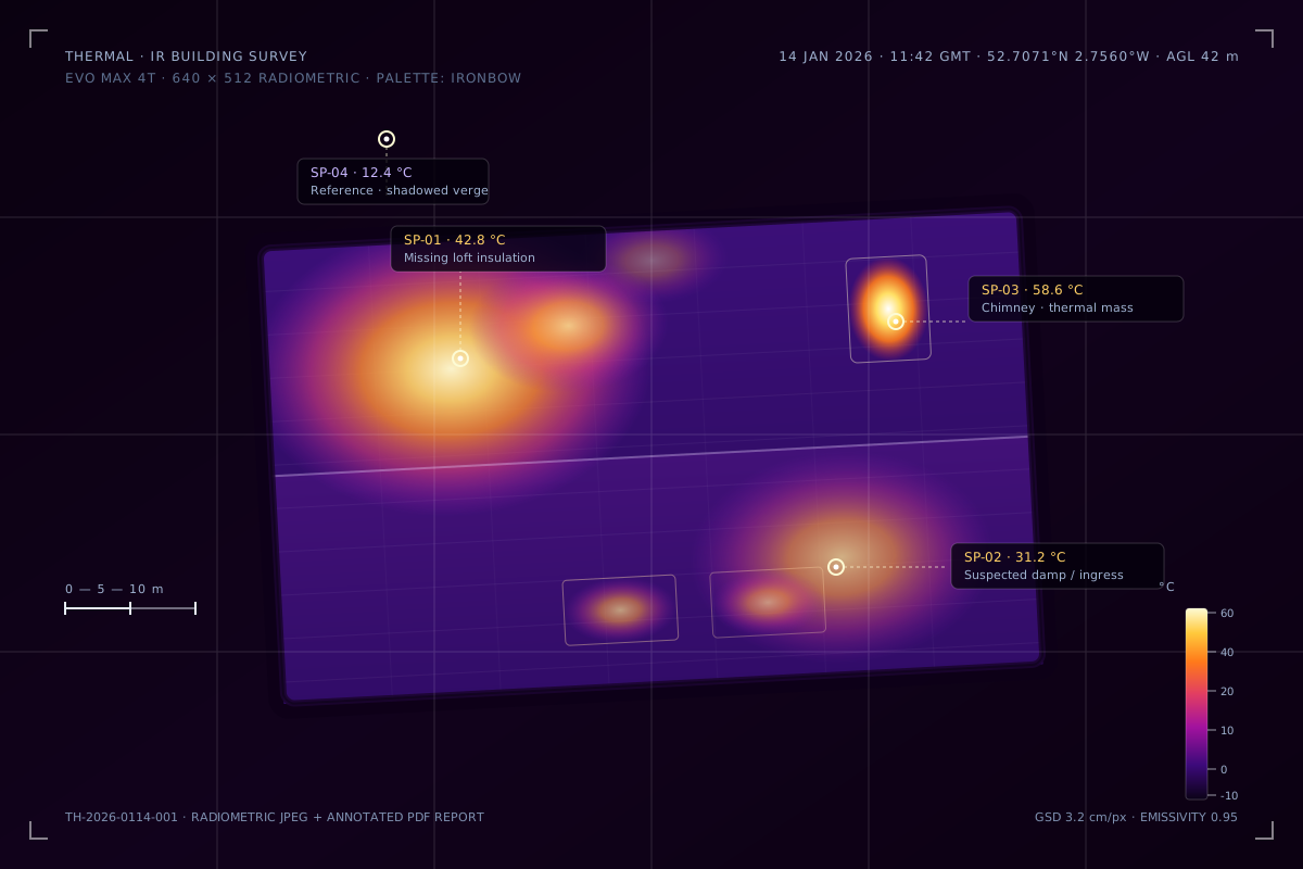
Radiometric thermal image of a residential roof showing heat loss, damp and a warm chimney with spot temperature callouts

Deliverable · Thermal

Radiometric thermal, not just colours.

Every frame is a measurement. Our 640 × 512 VOx sensor stores a temperature value in every pixel, so you can quantify heat loss and electrical faults — not just look at them.

  • Spot and area temperatures, ±2 °C or ±2% accuracy
  • GPS position and timestamp on every frame
  • Ironbow, rainbow or white-hot palettes
Radiometric JPEG Annotated PDF Thermal orthomosaic

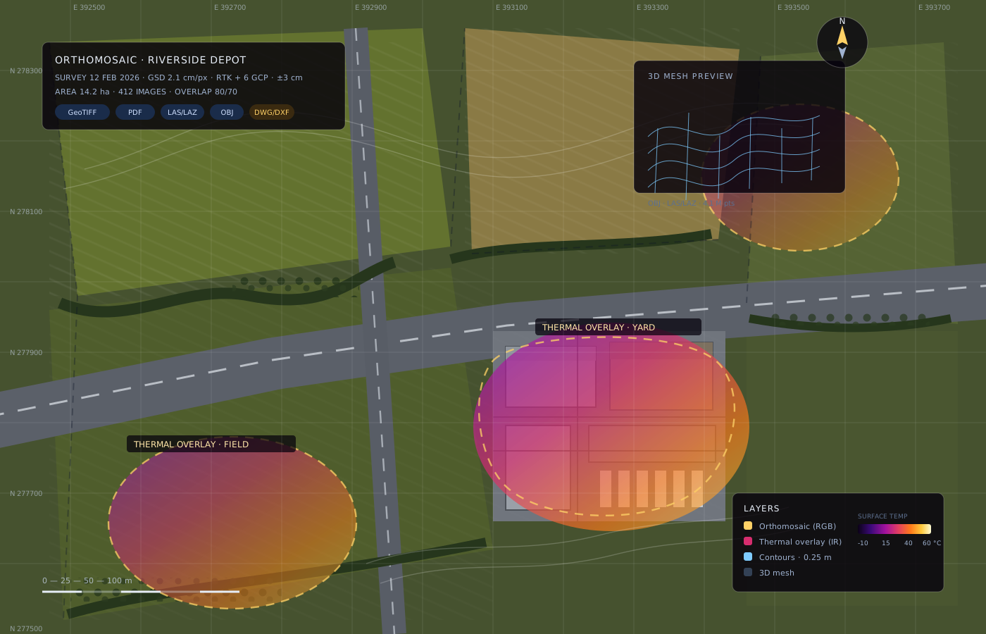
Deliverable · Mapping

Photogrammetry with thermal overlay.

We fly a programmed grid, process hundreds of overlapping frames and register the thermal layer to the visual orthomosaic. One map, two data sets: see what a site looks like — and how it performs.

  • Ground sampling down to 2 cm per pixel
  • RTK positioning plus ground control points
  • Opens in QGIS, ArcGIS and AutoCAD
GeoTIFF OBJ LAS/LAZ DWG/DXF
Orthomosaic map deliverable with thermal overlay layer, contours, coordinate grid and 3D mesh preview
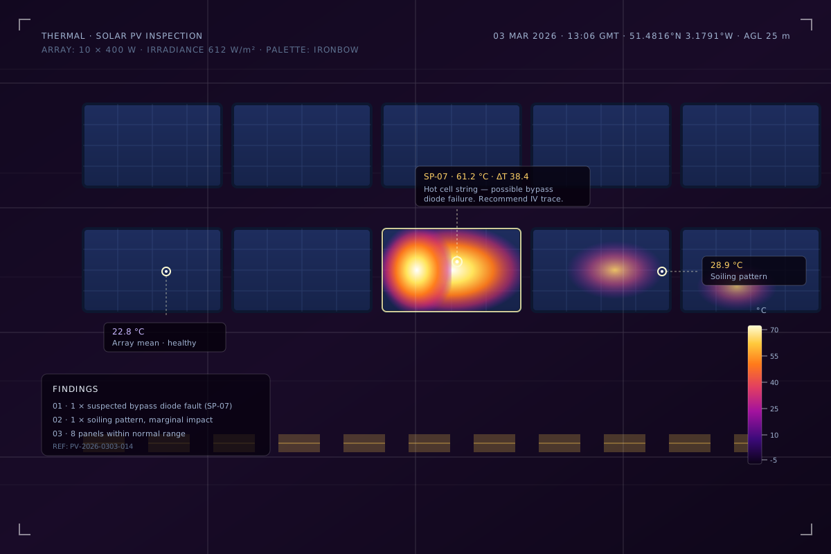
Thermal image of a rooftop solar array with a hotspot at 61.2 degrees Celsius and a 38.4 degree delta T annotation
Solar PV inspection Bypass diode fault · ΔT 38.4 °C
Autel EVO Max 4T controller showing an automated mapping mission with 3,600 square metre survey area and 134 planned photos
Automated mapping mission 3,600 m² · 134 photos

Equipment

Two drones. Chosen for the job, not the brochure.

We own both platforms outright. No rental delays, no unfamiliar payloads — and you always know exactly which sensor will be on site.

Full specifications
Close-up of the Autel EVO Max 4T gimbal with 50MP visual camera, thermal sensor and laser rangefinder

Autel EVO Max 4T

Primary platform

Thermal, photogrammetry and zoomed inspection in one airframe. The workhorse for surveys that need measurements, not just pictures.

Thermal sensor
640 × 512 radiometric VOx, ±2 °C
Visual camera
50MP 1/1.28" CMOS, 8K video
Zoom
10× optical, 160× max
Laser rangefinder
1.5 km range, ±1 m accuracy
DJI Mini 4K drone in flight

DJI Mini 4K

Lightweight platform

Sub-250 g visual platform for quick checks and confined or sensitive sites where the larger aircraft would be overkill.

Weight
249 g (sub-250 g class)
Camera
4K UHD, 3-axis gimbal
Flight time
31 minutes
Use cases
Confined spaces, low-risk visual checks
Autel EVO Max 4T operating in heavy rain

Built for British weather

IP43 rated, 12 m/s wind resistance, 42-minute endurance.

Surveys get scheduled, not cancelled. If conditions are unsafe we will tell you before the day, not on it.

Why us

A small team you can actually hold to account.

We own our equipment

The Autel EVO Max 4T and DJI Mini 4K are ours. We know them intimately. No rental delays, no unfamiliar payloads.

You deal with the pilot

When you book, you get the pilot who quoted. Not a subcontractor, not a marketplace freelancer.

We publish our pricing

No "contact us for a quote" games. You will see realistic ranges before you call.

We are CAA registered

CAA operator and flyer registration, A2 CofC in progress and £1M commercial public liability cover.

Pricing

Realistic ranges, published up front.

Every site is different, so we confirm a fixed price after a short conversation and a look at the location. No surprises, no day-rate roulette.

Typical price ranges by service
Service From
Thermal imaging survey £300
Mapping & photogrammetry £350
Roof & building inspection £175

Ranges are indicative for sites in and around Milton Keynes. Travel may apply further afield.

How it works

From enquiry to data in four steps.

  1. 01

    Tell us what you need

    A short call or form submission. We ask what decision the data needs to support.

  2. 02

    Survey plan & fixed quote

    We check airspace, permissions and site constraints, then confirm scope, price and date.

  3. 03

    Flight day

    I attend with the right aircraft. Most sites are flown within two hours.

  4. 04

    Data delivered

    Processed, checked and sent as the agreed formats — with a walkthrough if useful.

Ready to see what your site looks like from above?

Tell us what you need. We will tell you what is possible, what it costs, and how long it takes.